Category:Allée couverte et menhir de Prajou-Menhir
Jump to navigation
Jump to search
|
This building is classé au titre des monuments historiques de la France. It is indexed in the base Mérimée, a database of architectural heritage maintained by the French Ministry of Culture, under the reference PA00089669
|
| Object location | | View all coordinates using: OpenStreetMap |
|---|
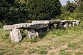
gallery grave in Trébeurden, France  | |||||
| Upload media | |||||
| Instance of | |||||
|---|---|---|---|---|---|
| Location | Trébeurden, Côtes-d'Armor, Brittany, Q88521114, Metropolitan France, France | ||||
| Heritage designation |
| ||||
 | |||||
Media in category "Allée couverte et menhir de Prajou-Menhir"
The following 23 files are in this category, out of 23 total.
-
 Allée couverte de Prajou - panoramio.jpg 1,600 × 1,200; 367 KB
-
 Allée couverte et menhir de Prajou-Menhir - 01.jpg 2,560 × 1,920; 3.31 MB
-
 Allée Prajou-Menhir 02.jpg 5,260 × 3,505; 17.08 MB
-
 Allée Prajou-Menhir 03.jpg 5,260 × 3,505; 16.28 MB
-
 Allée Prajou-Menhir 04.jpg 5,260 × 3,505; 12.44 MB
-
 Allée Prajou-Menhir01.jpg 5,260 × 3,505; 17.27 MB
-
 Dolmen at Ile Grande.jpg 3,264 × 2,448; 2.52 MB
-
 Dolmen at Ile-Grande.jpg 3,264 × 2,448; 2.46 MB
-
 Menhir de Prajou-Menhir 1.jpg 3,505 × 5,260; 15.04 MB
-
 Pleumeur-Bodou - Allée couverte en Pleumeur - AD22 - 16FI3802.jpg 1,623 × 1,036; 320 KB
-
 Prajou Menhir 1.JPG 2,592 × 1,944; 1.03 MB
-
 Prajou Menhir.JPG 2,592 × 1,944; 1.03 MB
-
Prajou-Menhir 01 (plan fixe 20sec).ogv 22 s, 1,920 × 1,080; 171.64 MB
-
Prajou-Menhir 02 (plan fixe 20sec).ogv 20 s, 1,920 × 1,080; 202.9 MB
-
Prajou-Menhir 03 (plan fixe 20sec).ogv 23 s, 1,920 × 1,080; 168.38 MB
-
 Prajou-Menhir 1.jpg 3,200 × 4,500; 14.21 MB
-
 Prajou-Menhir 2.jpg 4,500 × 3,200; 11.57 MB
-
 Trebeurden alc-prajou-menhir 02.jpg 4,596 × 3,696; 2.51 MB
-
 Trebeurden alc-prajou-menhir 03.jpg 4,608 × 3,072; 2.48 MB
-
 Trebeurden alc-prajou-menhir 04.jpg 3,072 × 4,608; 1.8 MB
-
 Trebeurden alc-prajou-menhir 05.jpg 3,072 × 4,608; 2.69 MB
-
 Trebeurden alc-prajou-menhir 06.jpg 7,554 × 3,048; 4.08 MB
-
 Trebeurden alc-prajou-menhir 11.jpg 4,608 × 3,072; 2.63 MB


